ESCI 7355 Applications of Space Based Geodesy
Tu & Th 09:40-11:05 AM
CERI House 4 Seminar Room

Instructor: Bob Smalley
Office hours: 2-4 M Th & Th

Whitmore Mountains WAGN GPS
        site
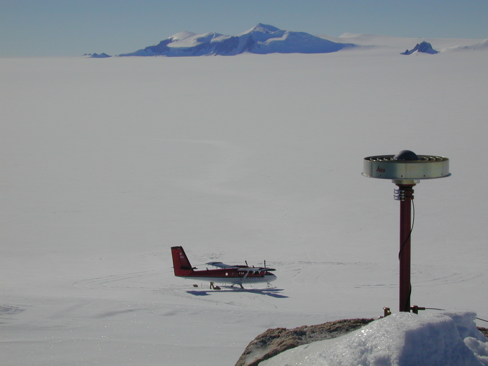
West Antarctic GPS Network site in the Whitmore Mountains, West Antarctica.


Course Description:


This course presents the theory and practice of GPS Geodesy with emphasis on detecting, quantifying, and modeling deformations of Earht associated with tectonic and geodynamic processes. The course will concentrate on GPS with introductions to INSAR, VLBI and SLR. The relationship to traditional geodesy and surveying is also developed. The course will cover  modeling and interpretation of the deformation data obtained.

Basic knowledge of the UNIX operating system and MATLAB is helpful (necessary!).


Texts:

There is no text.

Course requirements:

Students must attend all lectures. Class absences must be discussed PRIOR to the missed class.

Homework assignments must be handed in on time.

The class will include completing a computer based research project that uses the data and tools discussed in class. The project must be approved before starting work. Each student will give a 20 minute presentation the last day of class.

Grading:
70% homework, 10% class participation, 20% final project. There will be no final exam.
Project:
Each student will design, implement and present a small-scale data processing and analysis project using Space Based Geodetic data. The topic should be discussed with me, decided on and approved no later than October 19th. Each student will give a 20 minute PowerPoint presentation the last day of class. The project should be thoroughly documented and all scripts/programs/macros turned in as part of the project.
Classes:

        (Links open a pdf of the ppt file presented in class. The ppt files were made on a Mac and may not display properly - especially math - on a PC. The pdf files show the math correctly on the PC, but don't properly display slides with animation )
Aug    28    Tu    Class 1 - ppt, pdf
Aug    30    Th    Class 2 - ppt, pdf
Sep     4      Th    Class 3 - ppt, pdf
Sep     6      Tu    Class 4 - ppt, pdf
Sep     11    Tu    Class 5 - ppt, pdf
Sep     13    Th    Class 6 - ppt, pdf
Sep     18    Tu    Class 7 - ppt, pdf
Sep     20    Th    Class 8 - ppt, pdf
Sep     25    Tu    Class 9 - ppt, pdf
Sep     27    Th    Class 10 - ppt, pdf
Oct     2      Tu    Class 11 - ppt, pdf
Oct     4      Th    Class 12 - ppt, pdf
Oct     9      Tu    Class 13 - ppt, pdf
Oct     11    Tu    Class 14 - ppt, pdf
Oct     16    Tu    Fall Break - no class
Oct     18    Th    Class 15 - ppt, pdf
Oct     23    Tu    Class 16 - ppt, pdf
Oct     25    Th    Class 17 - GAMIT/GLOBK processing discussion - look at various links to GAMIT/GLOBK tutorials
Oct     30    Tu    Class 18 - ppt, pdf
Nov    1      Th    Class 19 - no class (USGS Midcontinent Geodesy Workshop)
Nov    6      Tu    Class 20 - no class (AAGG meeting)
Nov    8      Th    Class 21 - no class (AAGG meeting)
Nov   13     Tu    Class 22 - ppt, pdf
Nov   15     Th    Class 23 -
Nov   20     Tu    Class 24 - ppt
Nov   22     Th    Thanksgiving - NO CLASS
Nov   27     Tu    Class 25 -
Nov   29     Th    Class 26 - Projects
Dec      4    Tu    Class 27 - Projects (during AGU)

(I sometimes make changes to the notes presented in class - based on questions/comments during the class or because I found something interesting to add or something that needs correcting. The files at the links above are therefore not completely static during the semester.)


Homework (Assigned and due dates): (On Sept 14, the homework due day was changed from Tuesday to Thursday, since everyone is in class on Thursday.)

        Aug 28/Aug 30, - Read Li and Göetz for Aug 30, ESCI7355_Fall_2012_HW1a due Sept 6.

        Sep 6, Read Chapter 1 of NRCAN GPS Positioning Guide, look over Trimble GPS tutorial, Peter Dana's GPS Tutorial, read LTI, convolution, correlation (from http://mathtools.stanford.edu/ page http://mathtools.stanford.edu/reader.html), and ESCI7355_Fall_2012_HW2 due Sept 13.

        Sep 13, Read the three papers by Blewitt and the paper by Segall (link's below)

        Sep 25, Read Chapter 2 and 3 of NRCAN GPS Positioning Guide, read Chapter 8 and 9 of Guide to GPS Positioning (this "book" is a set of "overheads" with a page describing each overhead).

        Oct 9, Introduction to GAMIT processing - Read Units 1and 2 of Murray and Battalgia's GPS processing tutorial - Unit 1, Unit 2 - for Thursday Oct 11.
           I will provide by email, and in the following link, the CERI Mac lab specific setup info for the GAMIT exmaple we will do. gamit.cshrc
          Copy the folder "esci7205_pif_proc_dev" from my public directory on the mac lab system to your directory.
          This folder has both the data and scripts to process the data. We will work our way up to using the script.

        Oct 11, test of the GAMIT setup for access by the class using CERI Mac lab. Try running GAMIT. gamit.test.run


A day at WAIS
        Divide
A day at the West Antarctic Ice Sheet (WAIS) Divide Camp.

Additional files/link:


     CERI Computer information

      CERI Computer Network Facts (and some opinion) (from 2007, somewhat out of date)


GPS links

      Trimble GPS tutorial
      Peter Dana's GPS Tutorial
      Satellite Navigation and Positioning Lab (SNAP Lab)
      The GPS system - Kowoma.de
 
      NRCAN GPS Positioning Guide

      Sam Wormley's GPS Resources
      Mike Cramers - online GPS resources
      James R. Clynch GPS Geodesy Geophysics

      dated, but still useful textbook - Guide to GPS Positioning

      WIKI
      maps-gps-info

Geodesy

      Li and Göetz
      Mike Cramer's Geodesy page
      What Does Height Really Mean?
      coordinate conversions

Geodynamics

      GPS applications for geodynamics and earthquake studies, Segall and Davis

Geoff Blewitt's - intro GPS processing (theory)

      Basics of GPS
      GPS for Geodesy
      GPS Treatise

Eric Calias - GPS Geodesy notes

      Space Geodetic Measurements of Active Crustal Motions
      GPS orbits lecture
      GPS orbits lab

Kalman Filter (^%$^%* magic!)

      Poor man's introduction to the Kalman Filter - R. Du Plessis ("classic") 
      Welch and Bishop - Introduction
      Welch and Bishop - siggraph course
      Greg Czerniak's "Kalman Filters for Undergrads Part I: Linear Kalman Filters" , poorly documented, not very efficient, Matlab implementations of single variable example and multi-variable example
      Bill McCafferty: introduction-to-the-kalman-filter-part-i 
      Bill McCafferty: introduction-to-the-kalman-filter-part-ii 
      the broken link to Peter Maybeck’s Stochastic Models, Estimation, and Control, Vol. 1, Chapter 1 in Bill McCafferty: introduction-to-the-kalman-filter-part-i 


GPS Processing (practical)

      GAMIT page 
      Gamit setup and SOPAC/IGS data files   
      Gamit Tutorial (Tom Herring)
      Gamit script help files
      Murray and Battaglia's GPS tutorial this is based on a copy of the web page that I had saved (the original link to this tutorial/workshop, which dates to when the authors were at Berkeley, is long gone). I've removed dead and Berkeley specific links  from the original page.
      Eric Calais' Gamit introduction
      Andrew Newman's class notes


  GPS  Data

      SPOAC 
      UNAVCO Facility
      NOAA CORS
      Crustal Dynamics Data Information System (CDDIS), NASA
      International GNSS Service (IGS)
      EUREF Permanent Network
      Southern California Integrated GPS Network (SCIGN) data portal
      Bay Area Regional Deformation (BARD)
      Caltech Tectonics Observatory
      Red Argentina de Monitorio Satelital Continuo (RAMSAC), Argentina National GPS Network
      Australian Regional GPS Network (ARGN)
      SUOMInet
      Geographical Survey Institute Japan (GSI) - GEONET
     
      Survey Mode GPS California (SCEC)

      ITRF

GPS Processing Services

      AUSPOS
      SCOUT
      Natural Resources Canada
      Online Positioning User Service (OPUS) NGS

Modeling software

      Ocada paper 1
      Ocada paper 2
      Chinnery paper
      Angular Dislocation in Half Space, Comninou and Dunders
      Triangular Dislocation in Half Space with appendices, Meade
     

      3d-def, Gomberg and Ellis
      defnode, McCaffrey
      Coulomb 3.2, Toda, Lin, Stein, Sevilgen
      (USGS software page - collection USGS and other software)
      Visco1d, Pollitz
      New and Classic Block Modeling, Triangular dislocations, Brendan Meade
      Codes from CalTech
      Elastic and Viscoelastic deformation codes , Smith and Sandwell

      Pylith , PyLith is a finite element code for the solution of dynamic and quasi-static tectonic deformation problems, from CIG - Computational Infrastructure for Geodynamics

InSAR

      Intro - Pritchard
      Remote Sensing Tutorial (InSAR in Sect. 8)
      theory synthetic aperture radar: F Paul, Zurich
      UNAVCO short course

Other stuff

       Goup on Earth Oservations: Geohazard Supersites & Natural Laboratories
     
      Ben Horner-Johnson's GMT & Geophysics Links

      Honey Bee Dance (or Google on it or waggle dance)
      spherical harmonics - spg-sm2c.pdf

      Multiple (multidimensional) matrix multiplications, with array expansion enabled (Multiprod)
      Multiprod package

      Inversion Class - guest lecture GPS and earthquake location

      Fourier Transform Tutorial
      MIT OCW Biological Engineering 20.203: tutorial1, tutorial2
      DFT notes from Signal Processing Class.ppt, DFT notes from Signal Processing Class.pdf
      m file to make the good, bad and ugly fft output (from unknown source - I found this on the internet a long time ago, but I can't find it now - so here it is): good bad ugly fft.

      Linear filtering
      notes from CalTech - The Theory of Linear Prediction, P. P. Vaidyanathan

      Signal Processing
      The Scientists and Engineer's Guide to Digital Signal Processing - Introduction to digital signal processing with little to no math.
      Analysis of Time Series and Spatial Data (Geophysics 505/Math 587) - From Rick Aster, NMT, with lots of math.