Plate
Tectonics and Euler Poles
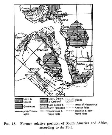
Historical
overview:
Plate tectonics is a uniting concept in Earth
Sciences, first put forward in the mid 1960's building on the idea of
Continental Drift.
Francis Bacon (1561-1620)
- Suggested Western Hemisphere once joined with
�In 1858
Snider-Pellegrini presented this map:
But idea developed most fully by Wegener in the
years after WW1.

The evidence for drifting continents was
largely based on:
�
continental
geometry
�
palaeoclimatelogy
�
palaeontological
provinces

�
structural
correlation
The mechanism for the drift was poorly defined,
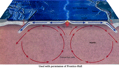
however it is important to note that Holmes suggested in the late 20's that mantle
convection may be involved, then�..
� 1944
Arthur Holmes authored the classic textbook, Principles
of Physical Geology.
 �
�
Following
an idea dating back to the 1830s, revitalised in the 1930s by himself, F.A. Vening
Meinesz and David Griggs, Holmes reintroduced thermal convection in the mantle
as a possible mechanism for continental drift.
� 1946
Harry H. Hess published his discovery of guyots,
flat-topped submarine volcanoes in the Pacific, which provided early evidence
for seafloor spreading.
� 1952
H.W. Menard and
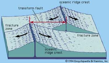
Robert S. Dietz discovered fracture zones in the Pacific Basin that were recognised
as being associated with lateral faulting. These zones later became significant
as a means of determining the direction of plate movement.
� 1954
Benioff and Wadati
defined down going slabs from earthquake foci:
� 1956
Maurice Ewing and Bruce Heezen, Lamont Geological
Observatory, reported that narrow troughs or rift valleys run along the crests
for most of the length of the extensive submarine mountain chains in the
Antarctic, Indian and
J. Hospers, S.K. Runcorn, K. Creer and
E. Irving, graduate students at
� 1959
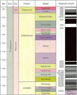
Allan Cox began paleomagnetic research that confirmed
the earlier work (1920s) of Motonari Matuyama, which concluded that the earth's
magnetic field had reversed during the early Pleistocene.
 ������
� 1962
Hess's
historic article, "History of the Ocean Basins,"
was published, suggesting that the continents do not plow through oceanic
crust, but are carried on mantle that is overturning due to thermal convection.
� 1963
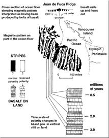
Fred Vine and Drummond Matthews
 �Vine
�Vine
of
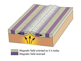 �
�
� 1964
J. Tuzo Wilson,
� 1965
Bullard, Everett and Smith of
� 1967
Dan McKenzie,
 �McKenzie
Scripps
Institute of Oceanography (now at
Robert Parker, Scripps, completed a computer
program called Supermap for plotting worldwide geophysical data using any
projection. He hit upon the idea of using a Mercator projection to plot plate
tectonics, which proved highly useful in later studies.
Today
Plate models are now generally accepted as
providing good descriptions for surface evolution of the oceanic regions.
The exact nature of plates, etc is less well
defined in some continental regions or in collision zones, where boundaries may
become diffuse (e.g. E Med, N Arabia,�
�"But the basic tenet of plate tectonics,
rigid-body movements of large plates of lithosphere, fails to apply to
continental interiors, where buoyant continental crust can detach from the
underlying mantle to form mountain ranges and broad zones of diffuse tectonic
activity."
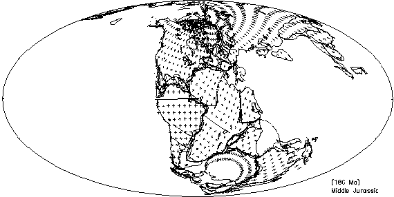
Nevertheless, plate tectonic models now allow
the palaeo-reconstruction of the gross relative distribution of large
continents blocks back to ~600 Ma. These reconstructions become more ambiguous
as one goes back beyond 200 Ma.
The reconstructions work at a regional scale as
well as a continental one. One of the first plate tectonic analyses of a
regional scale problem was presented by
Similar analyses are still underway for more
complex regions. More examples are discussed in for example Kearey & Vine in Chapters 6,7,8 and 9.
�
The Basic Framework
Click
here for more detailed notes.
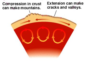
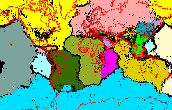
Plate tectonic theory assumes a relatively cool
rigid outer shell or LITHOSPHERE divided into a network of PLATES. The plates act
as stress guides. They move over the underlying, plastic ASTHENOSPHERE.
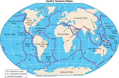
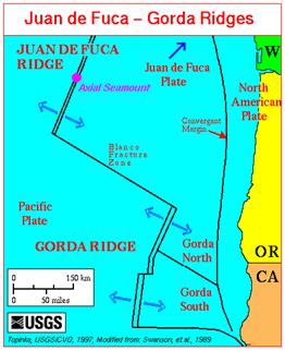
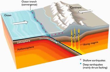
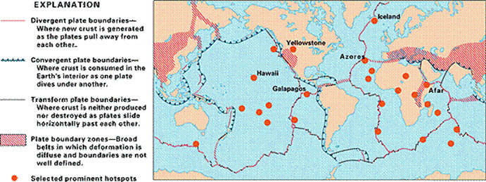
There are three types of margin between plates:
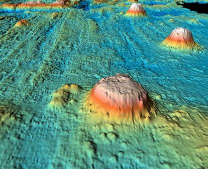
�������������������� -����� constructive � mid-ocean ridges
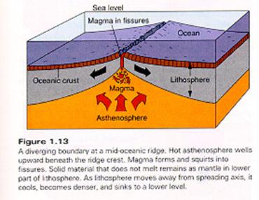
-
destructive
� subduction zones or trenches
-
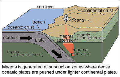
-
conservative
� transform faults
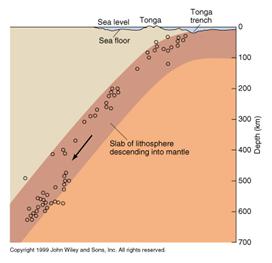
The different types of margin can be defined and
located by seismic studies.� Constructive
+ conservative -> shallow EQ, destructive have shallow, intermediate and
deep foci in a dipping Benioff zone.
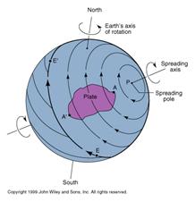
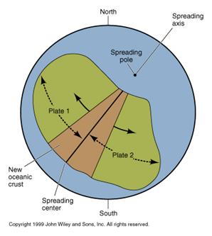
Plates move relative to each other. To describe
their motion on the surface of a spherical Earth, one needs to use Euler�s
�fixed point� theorem, which can be stated as:
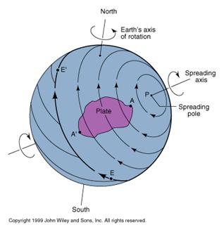
�The most general displacement of a rigid body over
the surface of a sphere can be regarded as a rotation about a suitable axis
which passes through the centre of that sphere. �
Thus all plate motions can be described by a rotation
axis, which passes through the centre of the Earth and cuts the surface at
two points, called the poles of rotation. The relative motion of two
plates then needs a pole of rotation and an angular velocity to be defined.
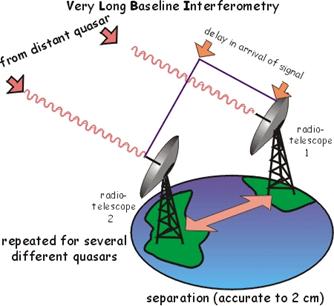
These can be determined in a number of ways
including direct measurements using satellite laser ranging, or very-long baseline
interferometry (VLBR) which uses the signal from quasars and terrestrial radio
telescopes as receivers.
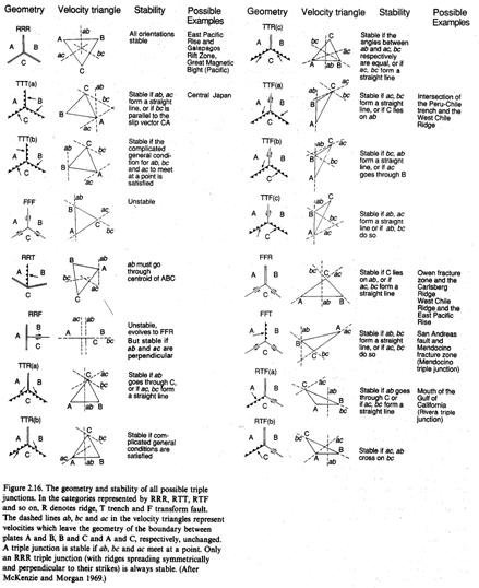
The basic geometry of plate motions has been
thoroughly analysed, and discussed in a number of classic papers, eg� McKenzie
& Morgan, Nature, 224, p 125-133, 1969 but see Cox and
Hart for a detailed discussion of the geometry of plate tectonics.
In addition to discussing the relative motions of
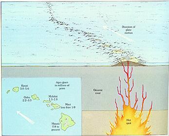
plates, one can also define plate motion relative to the Hot-Spot Reference Frame.
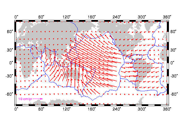
This gives a so-called Absolute Plate Motion
(see Fowler sec. 2.7), and is a guide to the motion of the lithosphere relative
to the underlying mantle. This will be of interest when discussing the forces
which drive plates.
Modern research shows that the hot spot
reference frame is not exact, as hot spots drift at a velocity of ~5 mm per
year.
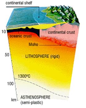
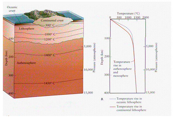
The Lithosphere
Exact details of what constitutes a plate are
complex, and the meaning of the term lithosphere is not well defined.� The plate is formed at spreading ridge and
thickens as it moves away and cools.
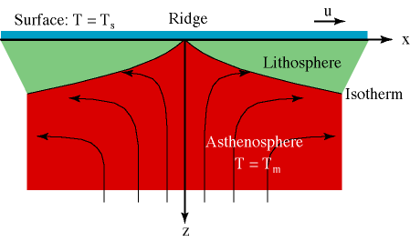
From seismic studies of the oceanic plates, the
boundary between the lithosphere and asthenosphere is often taken as the 4.3
kms-1 S-wave velocity contour. This boundary is often associated
with the point at which partial melting starts and the low velocity zone (LVZ)
begins. In this context therefore, the base of the lithosphere can be defined
by an isotherm (~1300 C).
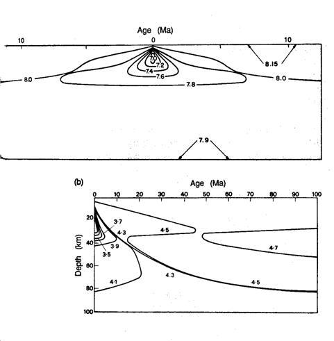
The figure below
shows calculated isotherms (black lines) with Tm - Ts =
1300C. The circles indicate the thickness of oceanic lithosphere in the
Pacific determined from seismic studies.
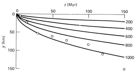
The thickness of the
lithosphere can be calculated by defining a thermal boundary layer where the
dimensionless temperature has fallen to 0.9:

The thickness of lithosphere in old cold
oceanic regions is ~100 km.
The base of the lithosphere under continental areas
is more variable and less distinct. Indeed the LVZ is not a globally ubiquitous
phenomena and is notably absent underneath Precambrian shield areas. As a
result, defining the thickness of continental lithosphere is difficult.
Estimates of the thickness of continental lithosphere have come however from
the analysis of the elastic rebound from unloading associated with the last
deglaciation event (see Peltier JGR,
89, p 11303-11316, 1984), which suggest thickness in excess of 200
km. Such deep roots to old continental areas are also suggest by seismic
tomographic studies (e.g.
Dzeiewonski and Woodhouse, Science,� 236,
p 37-48, 1987).

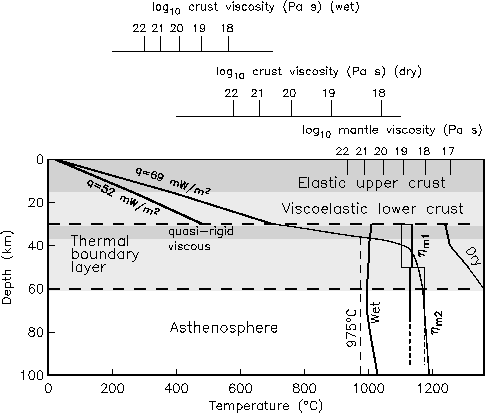
He stresses that only the shallow, colder part
of the plate can be considered rigid. This lithosphere has complex strength
structure, which is characterised by having a strong central layer which is the
part of the plate that can act as a stress guide.
The �elastic thickness� of a plate is a term
also used � it relates to this stronger part of the plate, but there is no
agreement on how to define it exactly. Values range from 5 to 130 km!
See this review from the Geoscientist (vol 16, 2006) on Continental
Crustal Rheology.
The Asthenosphere
This is the non-rigid part of the Earth, which readily
undergoes viscous flow. As will be inferred from the above discussion, the
detailed definition of the extent of the asthenosphere is very poor.�
Some associate it with the Low Velocity Zone,
others with the upper mantle not within plate, and some the whole mantle not in
plate. Seismic tomographic studies suggest that the entire mantle beneath the
lithosphere is dynamic, and so perhaps this latter definition is to be
preferred.
The problems with the definition of the terms
lithosphere and asthenosphere reflect the problems in defining boundaries
between parts of a rheological spectrum. Whether a material behaves as a rigid
or plastic body depends on its viscosity.
�Viscosity�
is a measure of how easily flow occurs when a material is subjected to
stress, and is defined by:
η� =� σ / (dε/dt)
where, η
= Viscosity (Pa.s); σ = Stress (Pa = Nm-2);� Strain rate = dε
/ dt (s-1).
Typical viscosities for liquids are - ηH2O� =� 10-3 Pas, ηPORRIDGE� =� 102
Pas, but ηMANTLE� ~� 1021 Pas as estimated from glacial
rebound studies.
More detailed results indicate that the LVZ has
η� approx. 4 x 10¹⁹
Pas, while the rest of the whole mantle has approx. constant η with range 1021 - 1022 Pas.
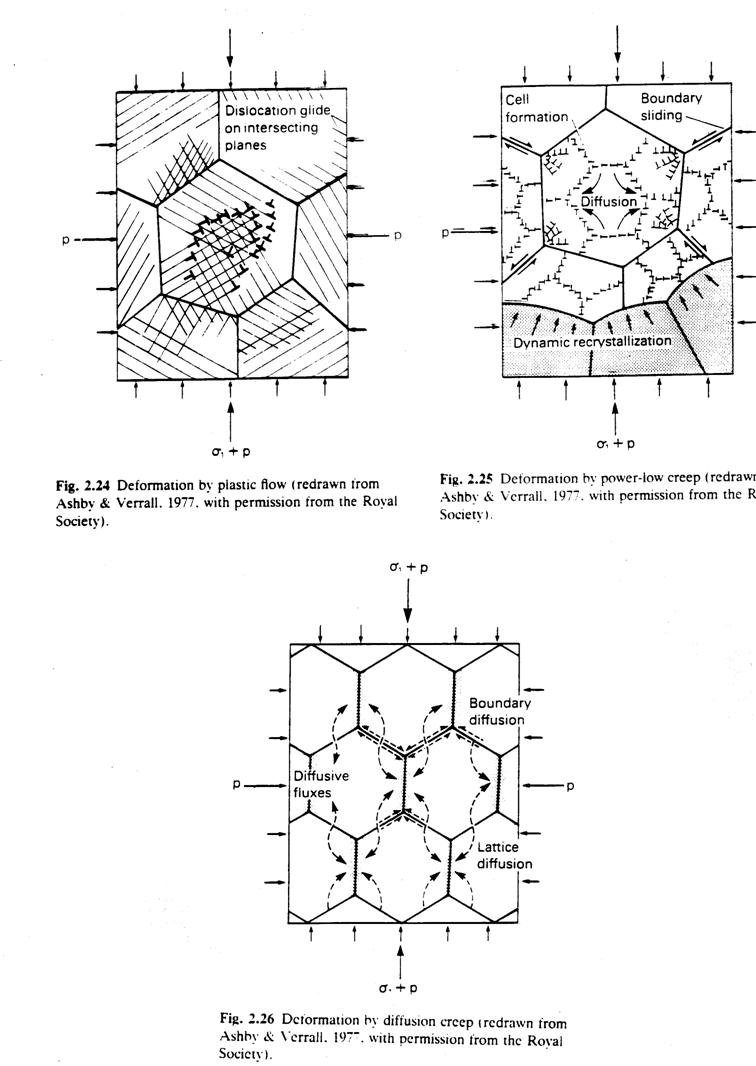
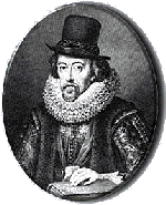
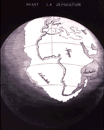
The viscosity depends on the mechanism of flow.
H2O is a liquid with no long range atomic order, but the mantle is crystalline. Once past the elastic limit
crystal creep occurs, either by dislocation glide + climb or by diffusional
flow involving atomic vacancy movement.

Both processes need atomic motion so they are thermally
activated, and so the viscosity of a rock or crystals is highly temperature
dependent. The cold lithosphere with �η -> ∞ is elastic and brittle, but hot mantle has
large but finite η and so can be plastic at geological strain
rates.