 |
| Characterizing the geometry and time of
deformation of the Meeman-Shelby Fault, Memphis TN |
|
Start Date: Jan 01, 2010
Funding: USGS
(NEHRP) - CEUS
End Date: Dec 31, 2011
|
|
Despite continuing studies
in geodesy, seismology, and paleoseismology in the
mid-continent/Mississippi
Embayment area, there remains a paradox regarding the documented series
of
relatively large seismic events and the apparent low rates of
deformation. As
both modeling and observational studies improve, a variety of
approaches are
beginning to bear fruit. A promising hypothesis proposed to solve the
apparent
paradox is that deformation may be focused in different areas at
different
times, and that the present seismicity might not reflect the long-term
behavior
of the fault system in the Central US. Mounting evidence, mainly from
paleoseismological studies, strongly suggests that the seismicity might
have
been migrating at least during the Holocene, although specific
structures
responsible for seismogenic faults other than the NMSZ system are not
well
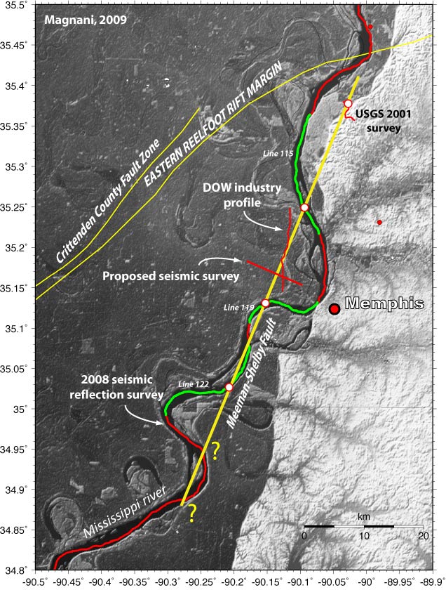
documented. In order to test the
hypothesis of migrating faults, a pilot study conducted in the
summer of 2008
collected 300 km of high-resolution seismic reflection data along the
Mississippi river, from Caruthersville, MO, to Helena, AR. The pilot
study was
a collaborative effort between NEHRP and the NSF/Tectonics program. The
data
identified with unprecedented resolution the existence of areas of
deformation
and faulting involving Quaternary sediments, several of which outside
of the
NMSZ. Following up on these results, the proposed project focuses on
the
southernmost of these structures, imaged along the Mississippi river
just 10 km
northwest of Memphis, TN. The river profile crosses the structure in
least at
three locations that align along a ~60 km-long NE-SW striking trend.
The
structure is characterized by a large ~60 m-high (at the top of
Cretaceous),
asymmetric anticline bounded to the east by a fault that displaces the
Paleozoic, Mesozoic and Cenozoic sediments, including the Holocene
deposits.
The imaged structure is interpreted as the southern continuation of the
Meeman-Shelby Fault zone (MSF) (Williams et al., 2001). No seismicity
is
observed today along this fault, although the deformation of Quaternary
deposits suggests that the fault has been active recently. The length
and the
Quaternary activity of this fault suggest that it might pose a more
serious
seismic hazard to Memphis than the NMSZ itself. The goal of this project is to image the onshore continuation of the recently imaged fault across the segment between two river crossings. The acquired high-resolution reflection seismic data will verify the location of the fault and help the characterization of the structure (style of faulting, variations in the third dimension). More importantly, identifying and imaging the fault on land will allow subsequent dating of key horizons through trenching, coring and geologic studies, providing the opportunity for bracketing the activity of the fault in time and to obtain age, amount of motions in the last events as well as recent slip rates. The project will open up several opportunities to investigate in detail the long-term behavior of this structure and contribute to the understanding of fault interactions in intraplate settings. |
| CERI Home |