Eastern United
States Infrastructure at Risk
A digital database and maps of approximately the central
third of the conterminous US showing elements of the built infrastructure
that could be at risk from a large earthquake in the New Madrid seismic zone.
Seismotectonics of
New Madrid seismic zone
A digital database and a series of maps showing seismicity
and sandblows, large geological structures interpreted from geophysical data,
locations of geophysical survey lines and modeling lines, the structure of
the Mississippi Valley graben, surficial and hydrologic features, and a synopsis
of seismotectonic features in the vicinity of New Madrid, Missouri.
Seismotectonics of
Wabash Valley seismic zone
A digital database and a series of maps of the Lower Wabash
Valley showing seismicity, earthquake intensities, selected wells and geophysical
survey and modeling lines, faults, igneous rocks, and geophysical and neotectonic
features, geologic materials, and infrastructure for emergency response planning.
Upper Mississippi
embayment Paleozoic and Precambrian rocks
Map showing structure contours to Precambrian strata within
and near the graben of the Reelfoot rift in the New Madrid seismic zone.
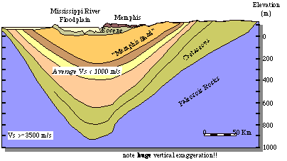
Memphis,
Shelby County Site Response Data
On-line database and a location map of a variety of site
response data (mostly shear-wave velocity profiles) measured and compiled
for the Memphis-Shelby County Hazard Mapping Project.
Shelby County
Subsurface Database
An on-line database information about geological, geotechnical,
and hydrological subsurface properties compiled from hundreds of well and
geotechnical boring logs. The database may be queried using ArcView
and viewed with a mapserver using any standard browser.
 Embayment Reference Model
Compilation of published literature
(i.e. references with summaries) and descriptions of work in progress (as
of 1999) related to characterizing features of the Mississippi embayment
that might affect earthquake ground motions.
|