|
Master File Reference: |
Reed, Silas (1843) |
|
Full Citation: |
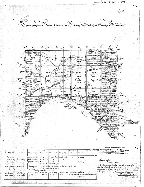
Reed. Silas Surveyor General (Map 1843). "Township 23 North of the base line, Range 16 East of the 5th principal Meridian," Township Plat, Southeast Missouri with survey field notes of H. W. Moulder, Deputy. [28x30cm. Scale 40 chains per inch or 1: 32,700. |
|
Compendium Entry Number: |
|
Compendium Location: |
New Madrid Compendium 3 Maps/Photo Archive |
|
Entry Type: |
Map |
|
Author(s): |
Reed, Silas |
|
Title: |
"Township 23 North of the base line, Range 16 East of the 5th principal Meridian," |
|
Date: |
1843 |
|
Dimensions and Scale |
28X30cm, Scale 40 chains per inch or 1:32,700 |
|
Source Information: |
Copied at Missouri Geological Survey by Kent Moran, July 2001. |
|
Compendium Entry: |
|
|
Value Synopsis: |
Value C+. An individual plat of the Township & Range (1820s-1850s) plat map collection for the New Madrid study area in Missouri and Arkansas. It is a separate entry in the Compendium because of a unique mapped feature, also noted in the field notes. In a location that today is in a cotton field just north of Big Oak Tree State Park, Missouri (~23 km NE of New Madrid), the surveyor, H.W. Molder, noted "an earthquake crack bears SW & NW. Cross said crack being about 48 inches deep." On the plat, however, the crack is drawn nearly east-west, perhaps bearing ENE at its eastern end. It is about 0.6 km long as drawn. Today, there is a definite "crease" in the field’s drainage that is approximately the right location, length and orientation to possibly represent the remnant trace of the 1811-12 earthquake fissure. See also Suter (Map, 1874) and Long (Map, 1822a,b) for other identified earthquake features on 19th century maps. |
|
Other Comments: |
|
|
Category Keywords: |
Map-Mississippi Embayment- topography and drainage |
|
Entry Information: |
|
|
Specific Subject: |
|
|
Specific Effect: |
|
|
Availability: |
JPG
scanned image (600x779 pixels, 123 Kb) JPG scanned image (1336x1775 pixels, 353 Kb) MrSID image (full size, 1.98 Mb) |